EditorialCreativeSportsCollectionsVideos
Prices
0Log in

Visual content for professionals.
800M+ images and videos.

Content Hub

  • Current Events
  • Pictures of the Year
  • Sports
  • Editorial
  • Creative
  • Collections
  • Videos

Offers

  • Prices & Packages
  • Promotions
  • Enterprise
  • Newsletter
  • Blog
  • The Game Magazine

Services

  • Content Research
  • Contract Photography
  • API & FTP Push
  • my-picturemaxx
  • Become a Partner

Company

  • About IMAGO
  • Careers
  • News

Help Center

  • FAQ
  • Contact Us
Legal NoticeTerms & ConditionsLicense InformationData PrivacyPrivacy Settings
© 2026 IMAGO
CEPICBAPLABVPA
  1. Forest fires in Alberta, Canada

Forest fires in Alberta, Canada

May 6, 2016

The following photos have been selected for you by the IMAGO picture desk on this topic. For more pictures please use the search function.
Images in this collection

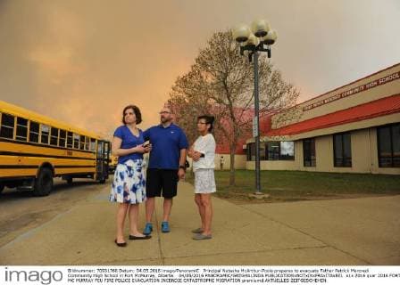
  • Principal Natasha McArthur-Poole prepares to evacuate Father Patrick Mercredi Community High School in Fort McMurray, Alberta. 04 05 2016 PANORAMIC GREGHALINDA

    Principal Natasha McArthur-Poole prepares to evacuate Father Patrick Mercredi Community High School in Fort McMurray, Alberta. 04 05 2016 PANORAMIC GREGHALINDA

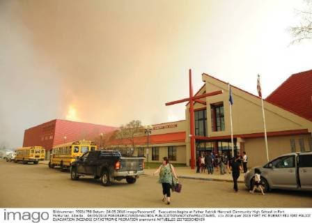
  • Evacuation begins at Father Patrick Mercredi Community High Schooll in Fort McMurray, Alberta. 04 05 2016 PANORAMIC GREGHALINDA

    Evacuation begins at Father Patrick Mercredi Community High Schooll in Fort McMurray, Alberta. 04 05 2016 PANORAMIC GREGHALINDA

  • Wildfire smoke visible from the playground at Ecole Dickinsfield School in Fort McMurray, Alberta, hours before the city was ordered evacuated. 04 05 2016 PANORAMIC GREGHALINDA

    Wildfire smoke visible from the playground at Ecole Dickinsfield School in Fort McMurray, Alberta, hours before the city was ordered evacuated. 04 05 2016 PANORAMIC GREGHALINDA

  • Wildfire smoke visible from the playground at Ecole Dickinsfield School in Fort McMurray, Alberta, hours before the city was ordered evacuated. 04 05 2016 PANORAMIC GREGHALINDA

    Wildfire smoke visible from the playground at Ecole Dickinsfield School in Fort McMurray, Alberta, hours before the city was ordered evacuated. 04 05 2016 PANORAMIC GREGHALINDA

  • Wildfire smoke visible from the playground at Ecole Dickinsfield School in Fort McMurray, Alberta, hours before the city was ordered evacuated. 04 05 2016 PANORAMIC GREGHALINDA

    Wildfire smoke visible from the playground at Ecole Dickinsfield School in Fort McMurray, Alberta, hours before the city was ordered evacuated. 04 05 2016 PANORAMIC GREGHALINDA

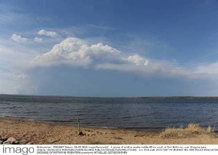
  • A plume of wildfire smoke visible 45 km south of Fort McMurray over Gregoire Lake, Alberta. 04 05 2016 PANORAMIC GREGHALINDA

    A plume of wildfire smoke visible 45 km south of Fort McMurray over Gregoire Lake, Alberta. 04 05 2016 PANORAMIC GREGHALINDA

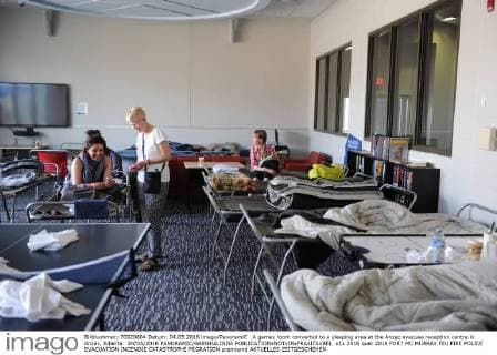
  • A games room converted to a sleeping area at the Anzac evacuee reception centre in Anzac, Alberta. 04 05 2016 PANORAMIC GREGHALINDA

    A games room converted to a sleeping area at the Anzac evacuee reception centre in Anzac, Alberta. 04 05 2016 PANORAMIC GREGHALINDA

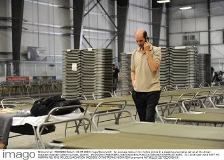
  • An evacuee talks on his mobile phone in a sleeping area being set up at the Anzac evacuee reception centre in Anzac, Alberta. 04 05 2016 PANORAMIC GREGHALINDA

    An evacuee talks on his mobile phone in a sleeping area being set up at the Anzac evacuee reception centre in Anzac, Alberta. 04 05 2016 PANORAMIC GREGHALINDA

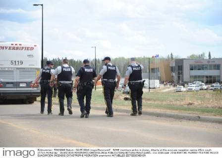
  • RCMP members arrive in Anzac, Alberta at the evacuee reception centre 45km south of Fort McMurray. 04 05 2016 PANORAMIC GREGHALINDA

    RCMP members arrive in Anzac, Alberta at the evacuee reception centre 45km south of Fort McMurray. 04 05 2016 PANORAMIC GREGHALINDA

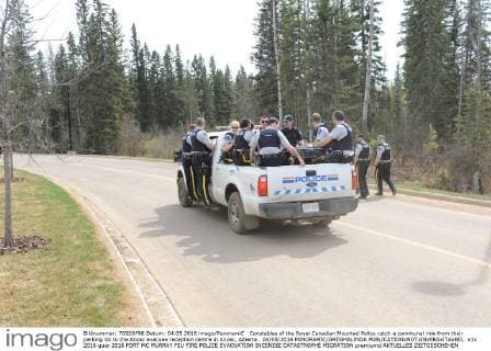
  • Constables of the Royal Canadian Mounted Police catch a communal ride from their parking lot to the Anzac evacuee reception centre in Anzac, Alberta. 04 05 2016 PANORAMIC GREGHALINDA

    Constables of the Royal Canadian Mounted Police catch a communal ride from their parking lot to the Anzac evacuee reception centre in Anzac, Alberta. 04 05 2016 PANORAMIC GREGHALINDA

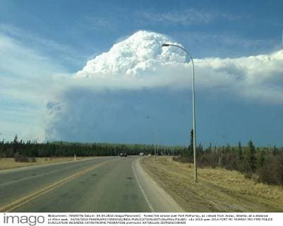
  • Forest fire smoke over Fort McMurray, as viewed from Anzac, Alberta, at a distance of 45km east. 04 05 2016 PANORAMIC GREGHALINDA

    Forest fire smoke over Fort McMurray, as viewed from Anzac, Alberta, at a distance of 45km east. 04 05 2016 PANORAMIC GREGHALINDA

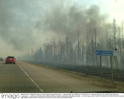
  • Vehicles flee Fort McMurray southwards on Alberta Highway 63, passing the Gregoire subdivision. 04 05 2016 PANORAMIC GREGHALINDA

    Vehicles flee Fort McMurray southwards on Alberta Highway 63, passing the Gregoire subdivision. 04 05 2016 PANORAMIC GREGHALINDA

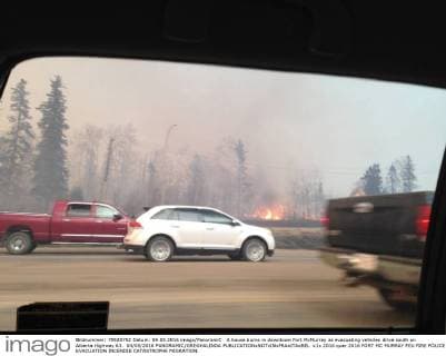
  • A house burns in downtown Fort McMurray as evacuating vehicles drive south on Alberta Highway 63. 04 05 2016 PANORAMIC GREGHALINDA

    A house burns in downtown Fort McMurray as evacuating vehicles drive south on Alberta Highway 63. 04 05 2016 PANORAMIC GREGHALINDA

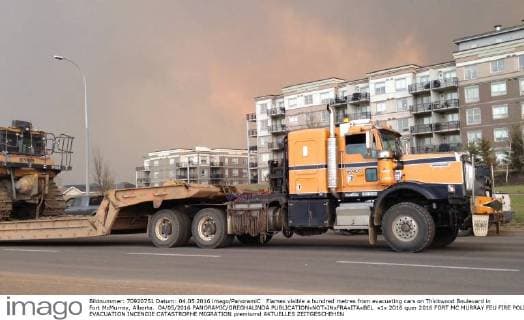
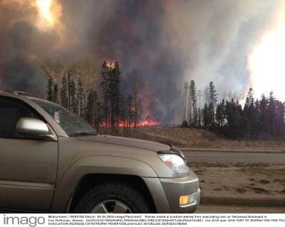
  • Flames visible a hundred metres from evacuating cars on Thickwood Boulevard in Fort McMurray, Alberta. 04 05 2016 PANORAMIC GREGHALINDA

    Flames visible a hundred metres from evacuating cars on Thickwood Boulevard in Fort McMurray, Alberta. 04 05 2016 PANORAMIC GREGHALINDA

  • Flames visible a hundred metres from evacuating cars on Thickwood Boulevard in Fort McMurray, Alberta. 04 05 2016 PANORAMIC GREGHALINDA

    Flames visible a hundred metres from evacuating cars on Thickwood Boulevard in Fort McMurray, Alberta. 04 05 2016 PANORAMIC GREGHALINDA

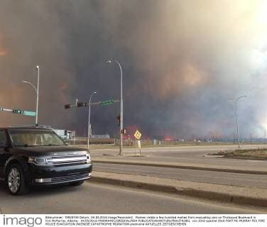
  • Flames visible a few hundred metres from evacuating cars on Thickwood Boulevard in Fort McMurray, Alberta. 04 05 2016 PANORAMIC GREGHALINDA

    Flames visible a few hundred metres from evacuating cars on Thickwood Boulevard in Fort McMurray, Alberta. 04 05 2016 PANORAMIC GREGHALINDA

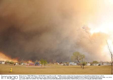
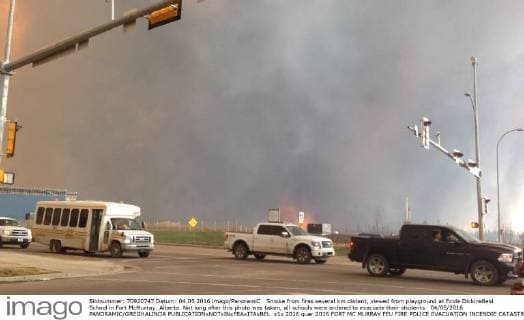
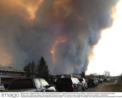
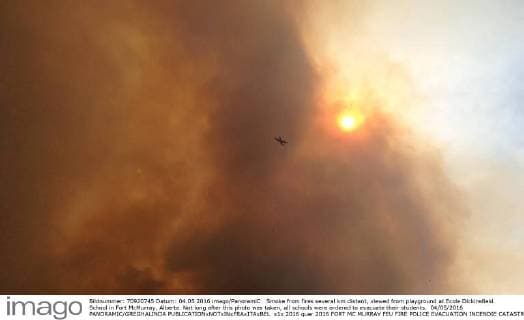
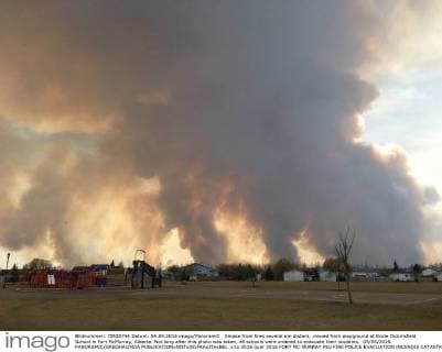
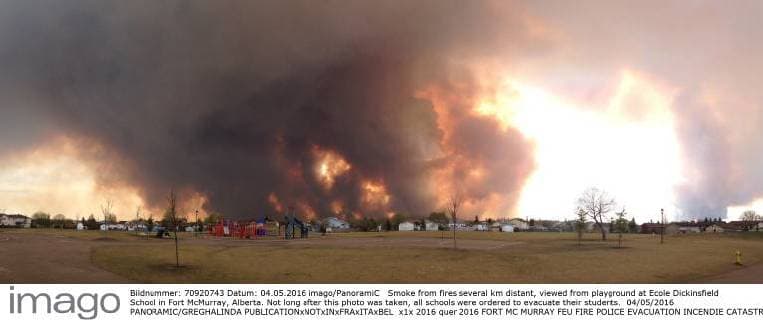
  • Smoke from fires several km distant, viewed from playground at Ecole Dickinsfield School in Fort McMurray, Alberta. Not long after this photo was taken, all schools were ordered to evacuate their students. 04 05 2016 PANORAMIC GREGHALINDA

    Smoke from fires several km distant, viewed from playground at Ecole Dickinsfield School in Fort McMurray, Alberta. Not long after this photo was taken, all schools were ordered to evacuate their students. 04 05 2016 PANORAMIC GREGHALINDA

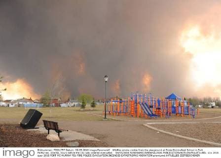
  • Smoke from fires several km distant, viewed from playground at Ecole Dickinsfield School in Fort McMurray, Alberta. Not long after this photo was taken, all schools were ordered to evacuate their students. 04 05 2016 PANORAMIC GREGHALINDA

    Smoke from fires several km distant, viewed from playground at Ecole Dickinsfield School in Fort McMurray, Alberta. Not long after this photo was taken, all schools were ordered to evacuate their students. 04 05 2016 PANORAMIC GREGHALINDA

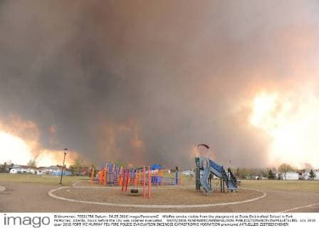
  • Smoke from fires several km distant, viewed from playground at Ecole Dickinsfield School in Fort McMurray, Alberta. Not long after this photo was taken, all schools were ordered to evacuate their students. 04 05 2016 PANORAMIC GREGHALINDA

    Smoke from fires several km distant, viewed from playground at Ecole Dickinsfield School in Fort McMurray, Alberta. Not long after this photo was taken, all schools were ordered to evacuate their students. 04 05 2016 PANORAMIC GREGHALINDA

  • Smoke from fires several km distant, viewed from playground at Ecole Dickinsfield School in Fort McMurray, Alberta. Not long after this photo was taken, all schools were ordered to evacuate their students. 04 05 2016 PANORAMIC GREGHALINDA

    Smoke from fires several km distant, viewed from playground at Ecole Dickinsfield School in Fort McMurray, Alberta. Not long after this photo was taken, all schools were ordered to evacuate their students. 04 05 2016 PANORAMIC GREGHALINDA

  • Smoke from fires several km distant, viewed from playground at Ecole Dickinsfield School in Fort McMurray, Alberta. Not long after this photo was taken, all schools were ordered to evacuate their students. 04 05 2016 PANORAMIC GREGHALINDA

    Smoke from fires several km distant, viewed from playground at Ecole Dickinsfield School in Fort McMurray, Alberta. Not long after this photo was taken, all schools were ordered to evacuate their students. 04 05 2016 PANORAMIC GREGHALINDA

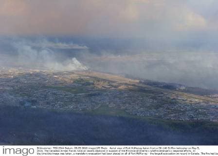
  • Aerial view of Fort McMurray taken from a CH-146 Griffon helicopter on May 5, 2016. The Canadian Armed Forces have air assets deployed in support of the Province of Alberta s wildfire emergency response efforts. At the time this image was taken, a mandatory evacuation had been placed on all of Fort McMurray - the largest evacuation on record in Canada. The fire had burned through nearly 77 square kilometers, razing neighborhoods across the city.  WAX2016050630 MCplxVanPutten

    Aerial view of Fort McMurray taken from a CH-146 Griffon helicopter on May 5, 2016. The Canadian Armed Forces have air assets deployed in support of the Province of Alberta s wildfire emergency response efforts. At the time this image was taken, a mandatory evacuation had been placed on all of Fort McMurray - the largest evacuation on record in Canada. The fire had burned through nearly 77 square kilometers, razing neighborhoods across the city. WAX2016050630 MCplxVanPutten

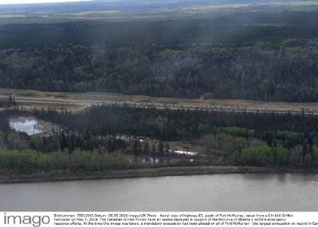
  • Aerial view of highway 63, south of Fort McMurray, taken from a CH-146 Griffon helicopter on May 5, 2016. The Canadian Armed Forces have air assets deployed in support of the Province of Alberta s wildfire emergency response efforts. At the time this image was taken, a mandatory evacuation had been placed on all of Fort McMurray - the largest evacuation on record in Canada. The fire had burned through nearly 77 square kilometers, razing neighborhoods across the city.  WAX2016050629 MCplxVanPutten

    Aerial view of highway 63, south of Fort McMurray, taken from a CH-146 Griffon helicopter on May 5, 2016. The Canadian Armed Forces have air assets deployed in support of the Province of Alberta s wildfire emergency response efforts. At the time this image was taken, a mandatory evacuation had been placed on all of Fort McMurray - the largest evacuation on record in Canada. The fire had burned through nearly 77 square kilometers, razing neighborhoods across the city. WAX2016050629 MCplxVanPutten

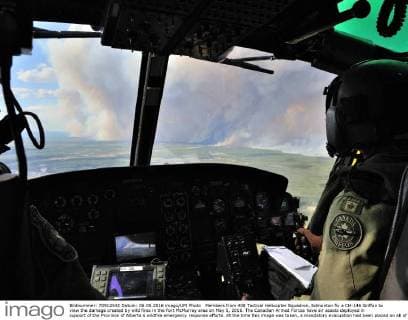
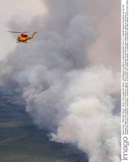
  • Members from 408 Tactical Helicopter Squadron, Edmonton fly a CH-146 Griffon to view the damage created by wild fires in the Fort McMurray area on May 5, 2016. The Canadian Armed Forces have air assets deployed in support of the Province of Alberta s wildfire emergency response efforts. At the time this image was taken, a mandatory evacuation had been placed on all of Fort McMurray - the largest evacuation on record in Canada. The fire had burned through nearly 77 square kilometers, razing neighborhoods across the city.  WAX2016050628 MCplxVanPutten

    Members from 408 Tactical Helicopter Squadron, Edmonton fly a CH-146 Griffon to view the damage created by wild fires in the Fort McMurray area on May 5, 2016. The Canadian Armed Forces have air assets deployed in support of the Province of Alberta s wildfire emergency response efforts. At the time this image was taken, a mandatory evacuation had been placed on all of Fort McMurray - the largest evacuation on record in Canada. The fire had burned through nearly 77 square kilometers, razing neighborhoods across the city. WAX2016050628 MCplxVanPutten

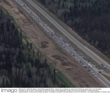
  • Aerial view of highway 63, south of Fort McMurray, taken from a CH-146 Griffon helicopter on May 5, 2016. The Canadian Armed Forces have air assets deployed in support of the Province of Alberta s wildfire emergency response efforts. At the time this image was taken, a mandatory evacuation had been placed on all of Fort McMurray - the largest evacuation on record in Canada. The fire had burned through nearly 77 square kilometers, razing neighborhoods across the city.  WAX2016050627 MCplxVanPutten

    Aerial view of highway 63, south of Fort McMurray, taken from a CH-146 Griffon helicopter on May 5, 2016. The Canadian Armed Forces have air assets deployed in support of the Province of Alberta s wildfire emergency response efforts. At the time this image was taken, a mandatory evacuation had been placed on all of Fort McMurray - the largest evacuation on record in Canada. The fire had burned through nearly 77 square kilometers, razing neighborhoods across the city. WAX2016050627 MCplxVanPutten

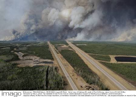
  • Aerial view of highway 63, south of Fort McMurray, taken from a CH-146 Griffon helicopter on May 5, 2016. The Canadian Armed Forces have air assets deployed in support of the Province of Alberta s wildfire emergency response efforts. At the time this image was taken, a mandatory evacuation had been placed on all of Fort McMurray - the largest evacuation on record in Canada. The fire had burned through nearly 77 square kilometers, razing neighborhoods across the city.  WAX2016050626 MCplxVanPutten

    Aerial view of highway 63, south of Fort McMurray, taken from a CH-146 Griffon helicopter on May 5, 2016. The Canadian Armed Forces have air assets deployed in support of the Province of Alberta s wildfire emergency response efforts. At the time this image was taken, a mandatory evacuation had been placed on all of Fort McMurray - the largest evacuation on record in Canada. The fire had burned through nearly 77 square kilometers, razing neighborhoods across the city. WAX2016050626 MCplxVanPutten

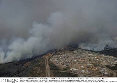
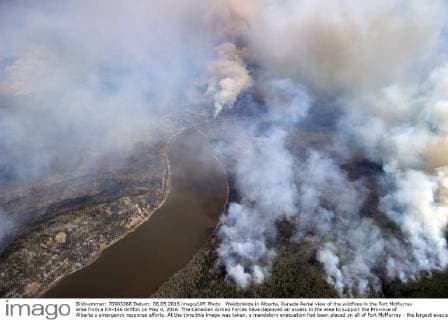
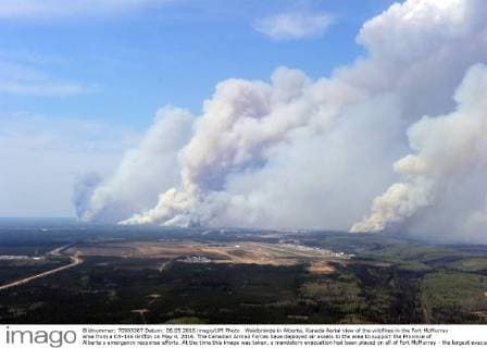
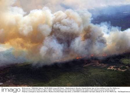
  • Waldbrände in Alberta, Kanada Aerial view of the wildfires in the Fort McMurray area from a CH-146 Griffon on May 4, 2016. The Canadian Armed Forces have deployed air assets to the area to support the Province of Alberta s emergency response efforts. At the time this image was taken, a mandatory evacuation had been placed on all of Fort McMurray - the largest evacuation on record in Canada. The fire had burned through nearly 77 square kilometers, razing neighborhoods across the city.  WAX2016050608 MCplxVanPutten

    Waldbrände in Alberta, Kanada Aerial view of the wildfires in the Fort McMurray area from a CH-146 Griffon on May 4, 2016. The Canadian Armed Forces have deployed air assets to the area to support the Province of Alberta s emergency response efforts. At the time this image was taken, a mandatory evacuation had been placed on all of Fort McMurray - the largest evacuation on record in Canada. The fire had burned through nearly 77 square kilometers, razing neighborhoods across the city. WAX2016050608 MCplxVanPutten

  • Waldbrände in Alberta, Kanada Aerial view of the wildfires in the Fort McMurray area from a CH-146 Griffon on May 4, 2016. The Canadian Armed Forces have deployed air assets to the area to support the Province of Alberta s emergency response efforts. At the time this image was taken, a mandatory evacuation had been placed on all of Fort McMurray - the largest evacuation on record in Canada. The fire had burned through nearly 77 square kilometers, razing neighborhoods across the city.  WAX2016050607 MCplxVanPutten

    Waldbrände in Alberta, Kanada Aerial view of the wildfires in the Fort McMurray area from a CH-146 Griffon on May 4, 2016. The Canadian Armed Forces have deployed air assets to the area to support the Province of Alberta s emergency response efforts. At the time this image was taken, a mandatory evacuation had been placed on all of Fort McMurray - the largest evacuation on record in Canada. The fire had burned through nearly 77 square kilometers, razing neighborhoods across the city. WAX2016050607 MCplxVanPutten

  • Waldbrände in Alberta, Kanada Aerial view of the wildfires in the Fort McMurray area from a CH-146 Griffon on May 4, 2016. The Canadian Armed Forces have deployed air assets to the area to support the Province of Alberta s emergency response efforts. At the time this image was taken, a mandatory evacuation had been placed on all of Fort McMurray - the largest evacuation on record in Canada. The fire had burned through nearly 77 square kilometers, razing neighborhoods across the city.  WAX2016050606 MCplxVanPutten

    Waldbrände in Alberta, Kanada Aerial view of the wildfires in the Fort McMurray area from a CH-146 Griffon on May 4, 2016. The Canadian Armed Forces have deployed air assets to the area to support the Province of Alberta s emergency response efforts. At the time this image was taken, a mandatory evacuation had been placed on all of Fort McMurray - the largest evacuation on record in Canada. The fire had burned through nearly 77 square kilometers, razing neighborhoods across the city. WAX2016050606 MCplxVanPutten

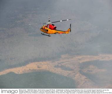
  • Waldbrände in Alberta, Kanada Members from 417 Combat Support Squadron survey the damage created by the wildfires in the Fort McMurray area on May 4, 2016. The Canadian Armed Forces have deployed air assets to the area to support the Province of Alberta s emergency response efforts. At the time this image was taken, a mandatory evacuation had been placed on all of Fort McMurray - the largest evacuation on record in Canada. The fire had burned through nearly 77 square kilometers, razing neighborhoods across the city.  WAX2016050605 MCplxVanPutten

    Waldbrände in Alberta, Kanada Members from 417 Combat Support Squadron survey the damage created by the wildfires in the Fort McMurray area on May 4, 2016. The Canadian Armed Forces have deployed air assets to the area to support the Province of Alberta s emergency response efforts. At the time this image was taken, a mandatory evacuation had been placed on all of Fort McMurray - the largest evacuation on record in Canada. The fire had burned through nearly 77 square kilometers, razing neighborhoods across the city. WAX2016050605 MCplxVanPutten

  • Waldbrände in Alberta, Kanada Aerial view of the wildfires in the Fort McMurray area from a CH-146 Griffon on May 4, 2016. The Canadian Armed Forces have deployed air assets to the area to support the Province of Alberta s emergency response efforts. At the time this image was taken, a mandatory evacuation had been placed on all of Fort McMurray - the largest evacuation on record in Canada. The fire had burned through nearly 77 square kilometers, razing neighborhoods across the city.  WAX2016050603 MCplxVanPutten

    Waldbrände in Alberta, Kanada Aerial view of the wildfires in the Fort McMurray area from a CH-146 Griffon on May 4, 2016. The Canadian Armed Forces have deployed air assets to the area to support the Province of Alberta s emergency response efforts. At the time this image was taken, a mandatory evacuation had been placed on all of Fort McMurray - the largest evacuation on record in Canada. The fire had burned through nearly 77 square kilometers, razing neighborhoods across the city. WAX2016050603 MCplxVanPutten

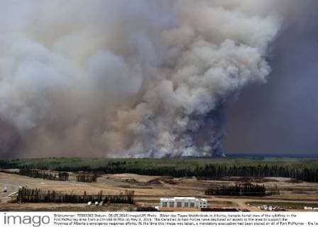
  • Bilder des Tages Waldbrände in Alberta, Kanada Aerial view of the wildfires in the Fort McMurray area from a CH-146 Griffon on May 4, 2016. The Canadian Armed Forces have deployed air assets to the area to support the Province of Alberta s emergency response efforts. At the time this image was taken, a mandatory evacuation had been placed on all of Fort McMurray - the largest evacuation on record in Canada. The fire had burned through nearly 77 square kilometers, razing neighborhoods across the city.  WAX2016050602 MCplxVanPutten

    Bilder des Tages Waldbrände in Alberta, Kanada Aerial view of the wildfires in the Fort McMurray area from a CH-146 Griffon on May 4, 2016. The Canadian Armed Forces have deployed air assets to the area to support the Province of Alberta s emergency response efforts. At the time this image was taken, a mandatory evacuation had been placed on all of Fort McMurray - the largest evacuation on record in Canada. The fire had burned through nearly 77 square kilometers, razing neighborhoods across the city. WAX2016050602 MCplxVanPutten

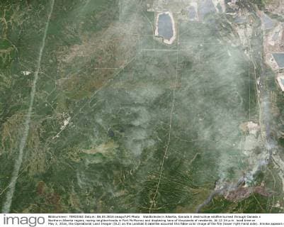
  • Waldbrände in Alberta, Kanada A destructive wildfire burned through Canada s Northern Alberta region, razing neighborhoods in Fort McMurray and displacing tens of thousands of residents. At 12:34 p.m. local time on May 3, 2016, the Operational Land Imager (OLI) on the Landsat 8 satellite acquired this false-color image of the fire (lower right-hand side). Smoke appears white and burned areas appear brown. When this image was acquired, the fire was burning southwest of downtown Fort McMurray. By the evening of May 3, the mandatory evacuation covered all of Fort McMurray - the largest evacuation on record in Canada. NASA  WAX2016050601 NASA......

    Waldbrände in Alberta, Kanada A destructive wildfire burned through Canada s Northern Alberta region, razing neighborhoods in Fort McMurray and displacing tens of thousands of residents. At 12:34 p.m. local time on May 3, 2016, the Operational Land Imager (OLI) on the Landsat 8 satellite acquired this false-color image of the fire (lower right-hand side). Smoke appears white and burned areas appear brown. When this image was acquired, the fire was burning southwest of downtown Fort McMurray. By the evening of May 3, the mandatory evacuation covered all of Fort McMurray - the largest evacuation on record in Canada. NASA WAX2016050601 NASA......

  • Waldbrände in Alberta, Kanada Members from 417 Combat Support Squadron survey the damage created by the wildfires in the Fort McMurray area on May 4, 2016. The Canadian Armed Forces have deployed air assets to the area to support the Province of Alberta s emergency response efforts. At the time this image was taken, a mandatory evacuation had been placed on all of Fort McMurray - the largest evacuation on record in Canada. The fire had burned through nearly 77 square kilometers, razing neighborhoods across the city.  WAX2016050604 MCplxVanPutten

    Waldbrände in Alberta, Kanada Members from 417 Combat Support Squadron survey the damage created by the wildfires in the Fort McMurray area on May 4, 2016. The Canadian Armed Forces have deployed air assets to the area to support the Province of Alberta s emergency response efforts. At the time this image was taken, a mandatory evacuation had been placed on all of Fort McMurray - the largest evacuation on record in Canada. The fire had burned through nearly 77 square kilometers, razing neighborhoods across the city. WAX2016050604 MCplxVanPutten

Collections
News