EditorialCreativeSportsCollectionsVideos
Prices
0Log in

Visual content for professionals.
800M+ images and videos.

Content Hub

  • Current Events
  • Pictures of the Year
  • Sports
  • Editorial
  • Creative
  • Collections
  • Videos

Offers

  • Prices & Packages
  • Promotions
  • Enterprise
  • Newsletter
  • Blog
  • The Game Magazine

Services

  • Content Research
  • Contract Photography
  • API & FTP Push
  • my-picturemaxx
  • Become a Partner

Company

  • About IMAGO
  • Careers
  • News

Help Center

  • FAQ
  • Contact Us
Legal NoticeTerms & ConditionsLicense InformationData PrivacyPrivacy Settings
© 2026 IMAGO
CEPICBAPLABVPA
  1. Satellite Images of Mexico and the Bahamas

Satellite Images of Mexico and the Bahamas

Aug 16, 2017

The following photos have been selected for you by the IMAGO picture desk on this topic. For more pictures please use the search function.
Images in this collection

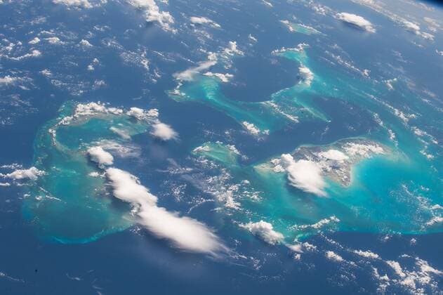
  • Bilder des Tages Aug 16, 2017 - Bahamas - Image Released Today: One of the most recognizable points on the Earth for astronauts to photograph is the Bahamas, captured in striking images many times from the vantage point of the International Space Station. Expedition 52 Flight Engineer Randy Bresnik of took this photo on Aug. 13, 2017, and shared it with his followers on social media. Bresnik said, The stunning Bahamas were a real treat for us. The vivid turquoise of the water over the reef was absolutely captivating. Bahamas - ZUMAz03_ 20170816_sha_z03_220 Copyright: xNASAx

    Bilder des Tages Aug 16, 2017 - Bahamas - Image Released Today: One of the most recognizable points on the Earth for astronauts to photograph is the Bahamas, captured in striking images many times from the vantage point of the International Space Station. Expedition 52 Flight Engineer Randy Bresnik of took this photo on Aug. 13, 2017, and shared it with his followers on social media. Bresnik said, The stunning Bahamas were a real treat for us. The vivid turquoise of the water over the reef was absolutely captivating. Bahamas - ZUMAz03_ 20170816_sha_z03_220 Copyright: xNASAx

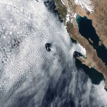
  • Aug 15, 2017 - Mexico - Image Released Today: In 1912, physicist Theodore von Karman first described a process that makes long, spiraling cloud patterns in the sky. These so-called von Karman vortices arise when winds are diverted around a blunt, high-profile area, often an island rising from the ocean. The alternating direction of rotation in the air forms swirls in the clouds. Satellites regularly spot these wind and cloud patterns around the world. On May 24, 2017, the Visible Infrared Imaging Radiometer Suite (VIIRS) on the Suomi NPP satellite captured a natural-color image of such swirls on the lee side of Guadalupe Island. The volcanic island rises from the Pacific Ocean off the coast of Baja Mexico - ZUMAz03_ 20170815_sha_z03_219 Copyright: xNASAxEarthxObservatoryx

    Aug 15, 2017 - Mexico - Image Released Today: In 1912, physicist Theodore von Karman first described a process that makes long, spiraling cloud patterns in the sky. These so-called von Karman vortices arise when winds are diverted around a blunt, high-profile area, often an island rising from the ocean. The alternating direction of rotation in the air forms swirls in the clouds. Satellites regularly spot these wind and cloud patterns around the world. On May 24, 2017, the Visible Infrared Imaging Radiometer Suite (VIIRS) on the Suomi NPP satellite captured a natural-color image of such swirls on the lee side of Guadalupe Island. The volcanic island rises from the Pacific Ocean off the coast of Baja Mexico - ZUMAz03_ 20170815_sha_z03_219 Copyright: xNASAxEarthxObservatoryx

Collections
News