EditorialCreativeSportsCollectionsVideos
Prices
0Log in

Visual content for professionals.
800M+ images and videos.

Content Hub

  • Current Events
  • Pictures of the Year
  • Sports
  • Editorial
  • Creative
  • Collections
  • Videos

Offers

  • Prices & Packages
  • Promotions
  • Enterprise
  • Newsletter
  • Blog
  • The Game Magazine

Services

  • Content Research
  • Contract Photography
  • API & FTP Push
  • my-picturemaxx
  • Become a Partner

Company

  • About IMAGO
  • Careers
  • News

Help Center

  • FAQ
  • Contact Us
Legal NoticeTerms & ConditionsLicense InformationData PrivacyPrivacy Settings
© 2026 IMAGO
CEPICBAPLABVPA
Back to collections

North Rhine-Westphalia: Low water levels on the Rhine

Jul 20, 2026

The following photos have been selected for you by the IMAGO picture desk on this topic. For more pictures please use the search function.
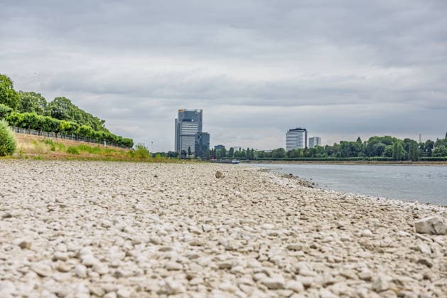
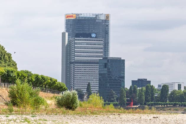
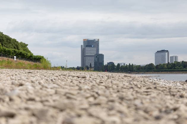
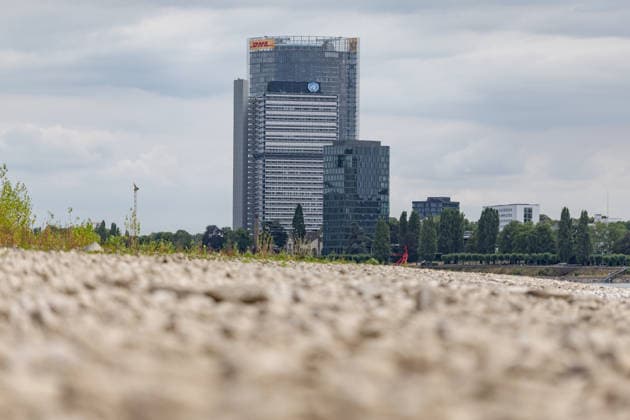
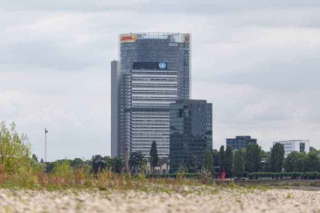
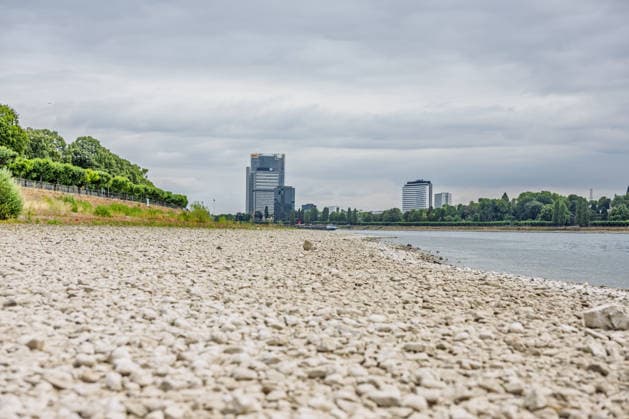
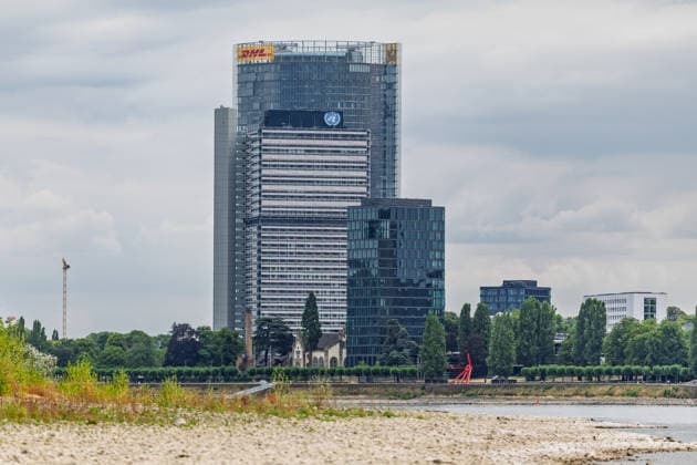
  • Niedrigwasser am Rhein vor dem UN Campus in Bonn Niedrigwasser am Rhein: Bei einem Pegelstand von 125 cm am Pegel Bonn liegt das Flussbett bis auf die tiefer liegende Fahrrinne trocken. Im Hintergrund das Hochhaus-Ensemble aus Post Tower, Langer Eugen und Climate Tower auf dem UN Campus, wo das Sekretariat der UN-Klimarahmenkonvention UNFCCC über den globalen Klimaschutz verhandelt. Bonn Beuel Nordrhein-Westfalen Deutschland *** Low Water Levels on the Rhine in Front of the UN Campus in Bonn Low Water Levels on the Rhine With the water level at 125 cm at the Bonn gauge, the riverbed is dry except for the lower-lying navigation channel. In the background is the high-rise complex consisting of the Post Tower, Langer Eugen, and Climate Tower Copyright: xMarcxJohnx
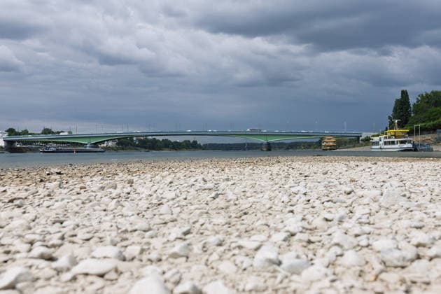
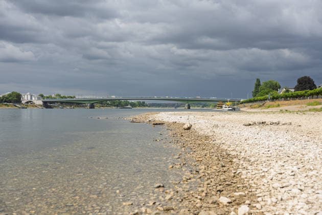
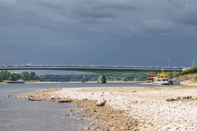
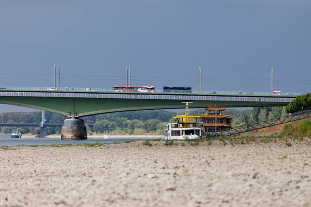
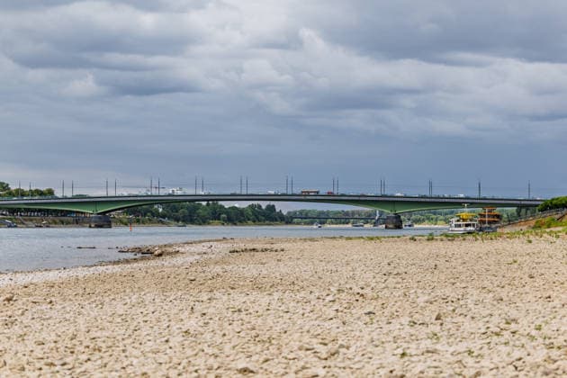
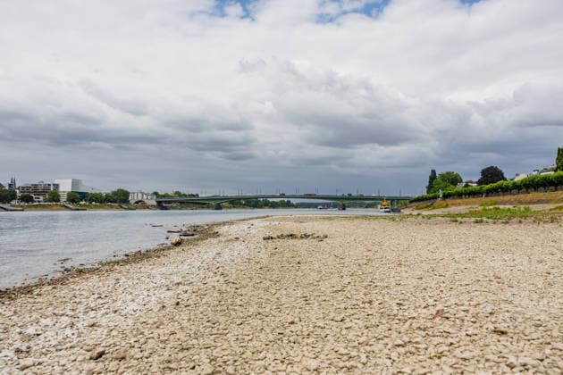
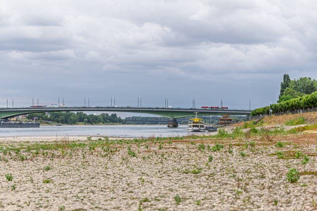
  • Niedrigwasser am Rhein in Bonn-Beuel Niedrigwasser am Rhein: Bei einem Pegelstand von 125 cm am Pegel Bonn liegt das Flussbett am Beueler Rheinufer bis auf die tiefer liegende Fahrrinne trocken. Blick nach Norden auf die stark befahrene Kennedybrücke, im Hintergrund die gesperrte Nordbrücke (Friedrich-Ebert-Brücke). Bonn Beuel Nordrhein-Westfalen Deutschland *** Low Water Levels on the Rhine in Bonn-Beuel Low Water Levels on the Rhine With the water level at the Bonn gauge station at 125 cm, the riverbed along the Beuel bank of the Rhine is dry except for the lower-lying navigation channel; view looking north toward the heavily trafficked Kennedy Bridge, with the closed Nordbrücke in the background. Friedrich Ebert Bridge, Bonn-Beuel, No Copyright: xMarcxJohnx
  • Niedrigwasser am Rhein vor dem UN Campus in Bonn Niedrigwasser am Rhein: Bei einem Pegelstand von 125 cm am Pegel Bonn liegt das Flussbett bis auf die tiefer liegende Fahrrinne trocken. Im Hintergrund das Hochhaus-Ensemble aus Post Tower, Langer Eugen und Climate Tower auf dem UN Campus, wo das Sekretariat der UN-Klimarahmenkonvention UNFCCC über den globalen Klimaschutz verhandelt. Bonn Beuel Nordrhein-Westfalen Deutschland *** Low Water Levels on the Rhine in Front of the UN Campus in Bonn Low Water Levels on the Rhine With the water level at 125 cm at the Bonn gauge, the riverbed is dry except for the lower-lying navigation channel. In the background is the high-rise complex consisting of the Post Tower, Langer Eugen, and Climate Tower Copyright: xMarcxJohnx
  • Niedrigwasser am Rhein in Bonn-Beuel Niedrigwasser am Rhein: Bei einem Pegelstand von 125 cm am Pegel Bonn liegt das Flussbett am Beueler Rheinufer bis auf die tiefer liegende Fahrrinne trocken. Blick nach Norden auf die stark befahrene Kennedybrücke, im Hintergrund die gesperrte Nordbrücke (Friedrich-Ebert-Brücke). Bonn Beuel Nordrhein-Westfalen Deutschland *** Low Water Levels on the Rhine in Bonn-Beuel Low Water Levels on the Rhine With the water level at the Bonn gauge station at 125 cm, the riverbed on the Beuel side of the Rhine is dry except for the lower-lying navigation channel; view looking north toward the heavily trafficked Kennedy Bridge, with the closed Nordbrücke in the background. Friedrich Ebert Bridge, Bonn-Beuel, North Copyright: xMarcxJohnx
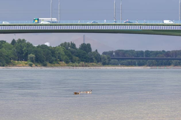
  • Niedrigwasser am Rhein in Bonn-Beuel Niedrigwasser am Rhein: Bei einem Pegelstand von 125 cm am Pegel Bonn liegt das Flussbett am Beueler Rheinufer bis auf die tiefer liegende Fahrrinne trocken. Blick nach Norden auf die stark befahrene Kennedybrücke, im Hintergrund die gesperrte Nordbrücke (Friedrich-Ebert-Brücke). Im Vordergrund eine Entenfamilie Bonn Beuel Nordrhein-Westfalen Deutschland *** Low Water Levels on the Rhine in Bonn Beuel Low Water Levels on the Rhine With the water level at the Bonn gauge station at 125 cm, the riverbed along the Beuel bank of the Rhine is dry except for the lower-lying navigation channel. View looking north toward the heavily trafficked Kennedy Bridge, with the closed Nordbrücke in the background; Fried Copyright: xMarcxJohnx
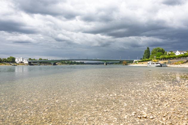
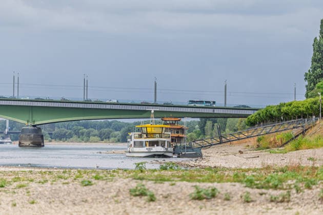
  • Niedrigwasser am Rhein in Bonn-Beuel Niedrigwasser am Rhein: Bei einem Pegelstand von 125 cm am Pegel Bonn liegt das Flussbett am Beueler Rheinufer bis auf die tiefer liegende Fahrrinne trocken. Blick nach Norden auf die stark befahrene Kennedybrücke, im Hintergrund die gesperrte Nordbrücke (Friedrich-Ebert-Brücke). Bonn Beuel Nordrhein-Westfalen Deutschland *** Low Water Levels on the Rhine in Bonn-Beuel Low Water Levels on the Rhine With the water level at the Bonn gauge station at 125 cm, the riverbed along the Beuel bank of the Rhine is dry except for the lower-lying navigation channel; view looking north toward the heavily trafficked Kennedy Bridge, with the closed Nordbrücke in the background. Friedrich Ebert Bridge, Bonn-Beuel, No Copyright: xMarcxJohnx
  • Niedrigwasser am Rhein in Bonn-Beuel Niedrigwasser am Rhein: Bei einem Pegelstand von 125 cm am Pegel Bonn liegt das Flussbett am Beueler Rheinufer bis auf die tiefer liegende Fahrrinne trocken. Blick nach Norden auf die stark befahrene Kennedybrücke, im Hintergrund die gesperrte Nordbrücke (Friedrich-Ebert-Brücke). Bonn Beuel Nordrhein-Westfalen Deutschland *** Low Water Levels on the Rhine in Bonn-Beuel Low Water Levels on the Rhine With the water level at the Bonn gauge station at 125 cm, the riverbed on the Beuel side of the Rhine is dry except for the lower-lying navigation channel; view looking north toward the heavily trafficked Kennedy Bridge, with the closed Nordbrücke in the background. Friedrich Ebert Bridge, Bonn-Beuel, North Copyright: xMarcxJohnx
  • Niedrigwasser am Rhein in Bonn-Beuel Niedrigwasser am Rhein: Bei einem Pegelstand von 125 cm am Pegel Bonn liegt das Flussbett am Beueler Rheinufer bis auf die tiefer liegende Fahrrinne trocken. Blick nach Norden auf die stark befahrene Kennedybrücke, im Hintergrund die gesperrte Nordbrücke (Friedrich-Ebert-Brücke). Bonn Beuel Nordrhein-Westfalen Deutschland *** Low Water Levels on the Rhine in Bonn-Beuel Low Water Levels on the Rhine With the water level at the Bonn gauge station at 125 cm, the riverbed on the Beuel side of the Rhine is dry except for the lower-lying navigation channel; view looking north toward the heavily trafficked Kennedy Bridge, with the closed Nordbrücke in the background. Friedrich Ebert Bridge, Bonn-Beuel, North Copyright: xMarcxJohnx
  • Niedrigwasser am Rhein in Bonn-Beuel Niedrigwasser am Rhein: Bei einem Pegelstand von 125 cm am Pegel Bonn liegt das Flussbett am Beueler Rheinufer bis auf die tiefer liegende Fahrrinne trocken. Blick nach Norden auf die stark befahrene Kennedybrücke, im Hintergrund die gesperrte Nordbrücke (Friedrich-Ebert-Brücke). Bonn Beuel Nordrhein-Westfalen Deutschland *** Low Water Levels on the Rhine in Bonn-Beuel Low Water Levels on the Rhine With the water level at the Bonn gauge station at 125 cm, the riverbed on the Beuel side of the Rhine is dry except for the lower-lying navigation channel; view looking north toward the heavily trafficked Kennedy Bridge, with the closed Nordbrücke in the background. Friedrich Ebert Bridge, Bonn-Beuel, North Copyright: xMarcxJohnx
  • Niedrigwasser am Rhein vor dem UN Campus in Bonn Niedrigwasser am Rhein: Bei einem Pegelstand von 125 cm am Pegel Bonn liegt das Flussbett bis auf die tiefer liegende Fahrrinne trocken. Im Hintergrund das Hochhaus-Ensemble aus Post Tower, Langer Eugen und Climate Tower auf dem UN Campus, wo das Sekretariat der UN-Klimarahmenkonvention UNFCCC über den globalen Klimaschutz verhandelt. Bonn Beuel Nordrhein-Westfalen Deutschland *** Low Water Levels on the Rhine in Front of the UN Campus in Bonn Low Water Levels on the Rhine With the water level at 125 cm at the Bonn gauge, the riverbed is dry except for the lower-lying navigation channel. In the background is the high-rise complex consisting of the Post Tower, Langer Eugen, and Climate Tower Copyright: xMarcxJohnx
  • Niedrigwasser am Rhein vor dem UN Campus in Bonn Niedrigwasser am Rhein: Bei einem Pegelstand von 125 cm am Pegel Bonn liegt das Flussbett bis auf die tiefer liegende Fahrrinne trocken. Im Hintergrund das Hochhaus-Ensemble aus Post Tower, Langer Eugen und Climate Tower auf dem UN Campus, wo das Sekretariat der UN-Klimarahmenkonvention UNFCCC über den globalen Klimaschutz verhandelt. Bonn Beuel Nordrhein-Westfalen Deutschland *** Low Water Levels on the Rhine in Front of the UN Campus in Bonn Low Water Levels on the Rhine With the water level at 125 cm at the Bonn gauge, the riverbed is dry except for the lower-lying navigation channel. In the background is the high-rise complex consisting of the Post Tower, Langer Eugen, and Climate Tower Copyright: xMarcxJohnx
  • Niedrigwasser am Rhein vor dem UN Campus in Bonn Niedrigwasser am Rhein: Bei einem Pegelstand von 125 cm am Pegel Bonn liegt das Flussbett bis auf die tiefer liegende Fahrrinne trocken. Im Hintergrund das Hochhaus-Ensemble aus Post Tower, Langer Eugen und Climate Tower auf dem UN Campus, wo das Sekretariat der UN-Klimarahmenkonvention UNFCCC über den globalen Klimaschutz verhandelt. Bonn Beuel Nordrhein-Westfalen Deutschland *** Low Water Levels on the Rhine in Front of the UN Campus in Bonn Low Water Levels on the Rhine With the water level at 125 cm at the Bonn gauge, the riverbed is dry except for the lower-lying navigation channel. In the background is the high-rise complex consisting of the Post Tower, Langer Eugen, and Climate Tower Copyright: xMarcxJohnx
  • Niedrigwasser am Rhein in Bonn-Beuel Niedrigwasser am Rhein: Bei einem Pegelstand von 125 cm am Pegel Bonn liegt das Flussbett am Beueler Rheinufer bis auf die tiefer liegende Fahrrinne trocken. Blick nach Norden auf die stark befahrene Kennedybrücke, im Hintergrund die gesperrte Nordbrücke (Friedrich-Ebert-Brücke). Bonn Beuel Nordrhein-Westfalen Deutschland *** Low Water Levels on the Rhine in Bonn-Beuel Low Water Levels on the Rhine With the water level at the Bonn gauge station at 125 cm, the riverbed on the Beuel side of the Rhine is dry except for the lower-lying navigation channel; view looking north toward the heavily trafficked Kennedy Bridge, with the closed Nordbrücke in the background. Friedrich Ebert Bridge, Bonn-Beuel, North Copyright: xMarcxJohnx
  • TITEL BESCHREIBUNG Bonn Beuel Nordrhein-Westfalen Deutschland *** TITLE DESCRIPTION Bonn Beuel North Rhine-Westphalia Germany Copyright: xMarcxJohnx
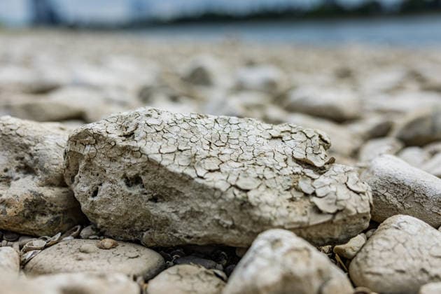
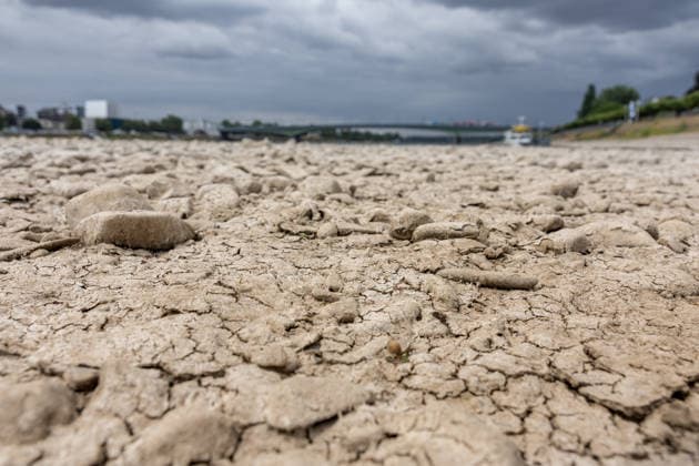
  • Niedrigwasser am Rhein vor dem UN Campus in Bonn Niedrigwasser am Rhein: Bei einem Pegelstand von 125 cm am Pegel Bonn liegt das Flussbett bis auf die tiefer liegende Fahrrinne trocken. Bonn Beuel Nordrhein-Westfalen Deutschland *** Low water levels on the Rhine in front of the UN Campus in Bonn Low water levels on the Rhine With the water level at the Bonn gauge station at 125 cm, the riverbed is dry except for the lower-lying navigation channel Bonn Beuel North Rhine-Westphalia Germany Copyright: xMarcxJohnx
  • Niedrigwasser am Rhein vor dem UN Campus in Bonn Niedrigwasser am Rhein: Bei einem Pegelstand von 125 cm am Pegel Bonn liegt das Flussbett bis auf die tiefer liegende Fahrrinne trocken. Im Hintergrund das Hochhaus-Ensemble aus Post Tower, Langer Eugen und Climate Tower auf dem UN Campus, wo das Sekretariat der UN-Klimarahmenkonvention UNFCCC über den globalen Klimaschutz verhandelt. Bonn Beuel Nordrhein-Westfalen Deutschland *** Low Water Levels on the Rhine in Front of the UN Campus in Bonn Low Water Levels on the Rhine With the water level at 125 cm at the Bonn gauge, the riverbed is dry except for the lower-lying navigation channel. In the background is the high-rise complex consisting of the Post Tower, Langer Eugen, and Climate Tower Copyright: xMarcxJohnx
  • Niedrigwasser am Rhein in Bonn-Beuel Niedrigwasser am Rhein: Bei einem Pegelstand von 125 cm am Pegel Bonn liegt das Flussbett am Beueler Rheinufer bis auf die tiefer liegende Fahrrinne trocken. Blick nach Norden auf die stark befahrene Kennedybrücke, im Hintergrund die gesperrte Nordbrücke (Friedrich-Ebert-Brücke). Bonn Beuel Nordrhein-Westfalen Deutschland *** Low Water Levels on the Rhine in Bonn-Beuel Low Water Levels on the Rhine With the water level at the Bonn gauge station at 125 cm, the riverbed on the Beuel side of the Rhine is dry except for the lower-lying navigation channel; view looking north toward the heavily trafficked Kennedy Bridge, with the closed Nordbrücke in the background. Friedrich Ebert Bridge, Bonn-Beuel, North Copyright: xMarcxJohnx
  • Niedrigwasser am Rhein in Bonn-Beuel Niedrigwasser am Rhein: Bei einem Pegelstand von 125 cm am Pegel Bonn liegt das Flussbett am Beueler Rheinufer bis auf die tiefer liegende Fahrrinne trocken. Blick nach Norden auf die stark befahrene Kennedybrücke, im Hintergrund die gesperrte Nordbrücke (Friedrich-Ebert-Brücke). Bonn Beuel Nordrhein-Westfalen Deutschland *** Low Water Levels on the Rhine in Bonn-Beuel Low Water Levels on the Rhine With the water level at the Bonn gauge station at 125 cm, the riverbed on the Beuel side of the Rhine is dry except for the lower-lying navigation channel; view looking north toward the heavily trafficked Kennedy Bridge, with the closed Nordbrücke in the background. Friedrich Ebert Bridge, Bonn-Beuel, North Copyright: xMarcxJohnx
  • Niedrigwasser am Rhein in Bonn-Beuel Niedrigwasser am Rhein: Bei einem Pegelstand von 125 cm am Pegel Bonn liegt das Flussbett am Beueler Rheinufer bis auf die tiefer liegende Fahrrinne trocken. Blick nach Norden auf die stark befahrene Kennedybrücke, im Hintergrund die gesperrte Nordbrücke (Friedrich-Ebert-Brücke). Bonn Beuel Nordrhein-Westfalen Deutschland *** Low Water Levels on the Rhine in Bonn-Beuel Low Water Levels on the Rhine With the water level at the Bonn gauge station at 125 cm, the riverbed on the Beuel side of the Rhine is dry except for the lower-lying navigation channel; view looking north toward the heavily trafficked Kennedy Bridge, with the closed Nordbrücke in the background. Friedrich Ebert Bridge, Bonn-Beuel, North Copyright: xMarcxJohnx